
-
Contents
-
Table of Contents
-
Bookmarks
Quick Links
Alpha
100 with T5
®
Owner’s Manual
June 2014
190-01771-00_0A
Printed in Taiwan
Related Manuals for Garmin Alpha 100
Summary of Contents for Garmin Alpha 100
-
Page 1
Alpha 100 with T5 ® Owner’s Manual June 2014 190-01771-00_0A Printed in Taiwan… -
Page 2
Garmin ® , the Garmin logo, Alpha ® , BlueChart ® , and City Navigator ® are trademarks of Garmin Ltd. or its subsidiaries, registered in the USA and other countries. -
Page 3: Table Of Contents
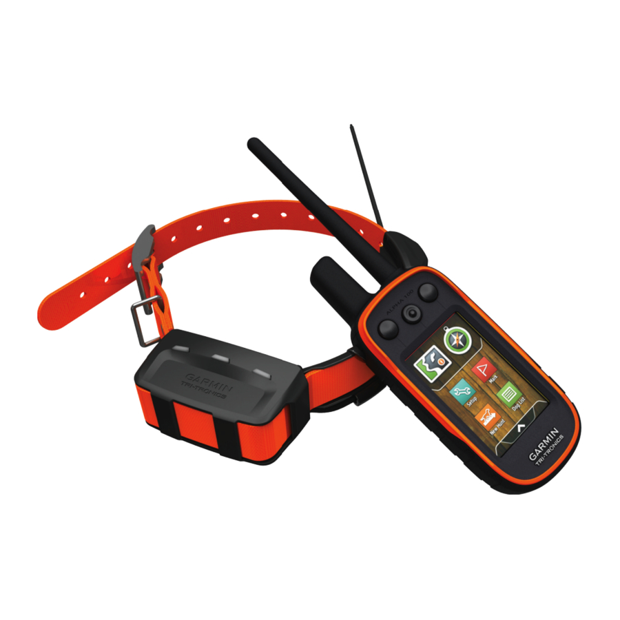
Setting Up the Alpha System …………. 1 Device Overviews …………..1 Waypoints ……………… 7 Alpha 100 Handheld Device ……….1 Marking Your Current Location ……….7 T5 Dog Collar Device …………1 Marking a Waypoint Using the Map ……..7 Getting More Information …………
-
Page 4
Device Care …………….13 Cleaning the Device …………13 Cleaning the Touchscreen ……….13 Specifications …………….13 Alpha 100 Handheld Device Specifications ……13 T5 Dog Collar Device Specifications ……..13 Battery Information …………..13 Long-Term Storage …………. 13 Maximizing the Battery Life ……….13 Saving Energy While Charging the Device …… -
Page 5: Getting Started
Signals). • Go to www.garmin.com/learningcenter. Attach the collar (Fitting the Collar on Your Dog). • Go to http://buy.garmin.com, or contact your Garmin dealer for information about optional accessories and replacement Device Overviews parts. Alpha 100 Handheld Device Registering Your Device Help us better support you by completing our online registration today.
-
Page 6: Charging The Handheld Device
Charging the Handheld Device • On the dog collar device, hold the power key until the status LED flashes and the collar beeps. NOTICE Turning Off the Devices To prevent corrosion, thoroughly dry the USB port, the weather • On the handheld device, hold the power key until the cap, and the surrounding area before charging or connecting to LCD display turns off.
-
Page 7: Vhf Radio Information
See the product Select Dog List. packaging or go to www.garmin.com/tracking-legal for details about the radio frequency of this product. Select a dog. Select Show Info > Reset > Yes.
-
Page 8: Setting Dog Alerts
If you are experiencing interference from other collars or automatically. After bark detection is enabled, you can set up a handheld devices in the area, you might need to change the ID bark alert (Setting Dog Alerts). for the dog. Communication with the Collar Select Dog List.
-
Page 9: Dog Status Icons
Before you can track your dogs and contacts using BaseCamp, Dog Training you must download BaseCamp to your computer (www.garmin.com/basecamp). You should research and investigate the training methods best suited for you, your dog, and your needs. This manual provides…
-
Page 10: Training Methods
Training Methods Bring the two handheld devices near each other, and select Yes on your handheld device. NOTE: Training features are not available in all areas for On the contact’s handheld device, select > Contacts > tracking collars. Pair. Tone: Activates an audible tone instead of stimulation. A tone On your handheld device, enter the name of the contact, and can be used as either a positive or negative training cue, select…
-
Page 11: Changing Your Contact Id
Changing Your Contact ID Select Show Info. Select > Adjust Collar Light. If you are experiencing interference from other collars or handheld devices in the area, you might need to change the Select Continuous, Blink Slow, or Blink Fast. contact ID for your handheld device. TIP: Select different light setting for each dog to help you Select Setup >…
-
Page 12: Increasing The Accuracy Of A Waypoint Location
Increasing the Accuracy of a Waypoint Location • To view the point on the map, select Review. You can refine a waypoint location for more accuracy. When • To change the order of the points on the route, select averaging, the device takes several readings at the same Move Up or Move Down.
-
Page 13: Navigating To The Start Of A Track
Setup Heading > Go To Line/Pointer > Course (CDI). Select an option. Sending and Receiving Data Wirelessly Before you can share data wirelessly, you must be within 10 feet (3 m) of a compatible Garmin device. You can share waypoints, geocaches, routes, and tracks wirelessly. Select >…
-
Page 14: Where To? Menu
course. The scale refers to the distance between dots Trip Computer the course deviation indicator, which tell you how far off course The trip computer displays your current speed, average speed, you are. maximum speed, trip odometer, and other helpful statistics. You can customize the trip computer layout, dashboard, and data Where To? Menu fields…
-
Page 15: Changing The Satellite View
Augmentation System/European Geostationary Navigation Select > Satellite > > Use With GPS Off. Overlay Service), or Demo Mode (GPS off). For more information about WAAS, go to http://www.garmin.com Simulating a Location /aboutGPS/waas.html. Select > Satellite > > Use With GPS Off.
-
Page 16: Setting The Device Tones
Day Highlight Color: Sets the color for selections made when Activity: Sets an activity for routing. The device calculates in day mode. routes optimized for the type of activity you are doing. Night Highlight Color: Sets the color for selections made when Route Transitions: Sets how the device routes from one point in night mode.
-
Page 17: Marine Map Settings
Records elevation changes over a period of time or Specifications distance, records barometric pressure over a period of time, Alpha 100 Handheld Device Specifications or records ambient pressure changes over a period of time. Calibrate Altimeter: Calibrates the altimeter.
-
Page 18: Saving Energy While Charging The Device
• GPX geocache files. Go to www.opencaching.com. You can select a longer duration for the update rate to conserve • GPI custom POI files from the Garmin POI Loader. Go to battery power. www.garmin.com/products/poiloader.
-
Page 19: Connecting The Handheld Device To A Computer
10 m (32.9 ft.) away from other ANT+ BaseCamp recognizes and transfers the collar’s internal accessories. track log. • Bring the Garmin device within range 3 m (10 ft.) of the ANT+ accessory. Deleting Files • After you pair the first time, your Garmin device automatically NOTICE recognizes the ANT+ accessory each time it is activated.
-
Page 20: T5 Battery Replacement Instructions
T5 Battery Replacement Instructions T5 Components Replace the battery cover. Replace the screws to secure the battery cover. Connect the battery connector and power connector. You may need to use a flat screwdriver to help secure the connectors. Select the power key to test the connections. When properly connected, a tone is emitted and the status LED blinks green.
-
Page 21: Changing The Fuse In The Vehicle Power Cable
Ascent — Total: The total elevation distance ascended since the last reset. Barometer: The calibrated current pressure. Battery Level: The remaining battery power. Bearing: The direction from your current location to a destination. You must be navigating for this data to appear. Cadence: The revolutions of the crank arm or strides per minute.
-
Page 22
Speed — Overall Avg.: The average speed while moving and stopped since the last reset. Sunrise: The time of sunrise based on your GPS position. Sunset: The time of sunset based on your GPS position. Time of Day: The current time of day based on your current location and time settings (format, time zone, daylight saving time). -
Page 23: Index
Index statistics 3 track and train codes 3 satellite signals 10, 11 tracking 4, 5 acquiring 2 tracks 3, 15 screen accessories 1, 15 training 6 locking 2 alarms training basics 5 settings 11 clock 10 type 3 settings 11–13 marine 13 update rate 14 sharing data 9 proximity 10 Sight ‘N Go 10 tones 12 software, updating 13 alerts 6 elevation 8, 10 specifications 13 dog 4 plot 10…
-
Page 24
+27 (0)11 251 9999 + 46 7744 52020 +886 2 2642-9199 ext 2 +49 (0)180 6 427646 0808 238 0000 20 ct./Anruf. a. d. +44 (0) 870 8501242 deutschen Festnetz, Mobilfunk max. 60 ct./Anruf 913-397-8200 1-800-800-1020 © 2014 Garmin Ltd. or its subsidiaries…
This manual is also suitable for:
T5
инструкцияGarmin Alpha 100

Alpha
™
100 and TT
™
10
Owner’s Manual
May 2013 190-01500-00_0B Printed in Taiwan
Посмотреть инструкция для Garmin Alpha 100 бесплатно. Руководство относится к категории GPS-устройства, 19 человек(а) дали ему среднюю оценку 8.5. Руководство доступно на следующих языках: английский. У вас есть вопрос о Garmin Alpha 100 или вам нужна помощь? Задайте свой вопрос здесь
- Table of Contents
- Getting Started
- Dog Collar Device Setup
- Dog Tracking
- Dog Training
- Contact Tracking
- Hunting with the Alpha System
- Waypoints, Routes, and Tracks
- Navigation
- Applications
- Customizing Your Device
- Device Information
- Appendix
- Index
Garmin Alpha 100 — это популярное устройство для глобального позиционирования (GPS), созданное компанией Garmin. Оно является навигационной системой, предназначенной для использования в спортивных и охотничьих целях. Устройство Garmin Alpha 100 оснащено высокочувствительной антенной принимателя GPS и гибкой системой управления, что позволяет пользователю точно определять свое местоположение в любых условиях.
Одной из главных особенностей Garmin Alpha 100 является функция отслеживания домашних животных, которая позволяет координировать местоположение собак на расстоянии. Устройство обладает возможностью создания и отслеживания до 20 собак одновременно, а также позволяет установить определенные границы, за которыми животное не может перемещаться.
Garmin Alpha 100 имеет яркий, четкий дисплей с высоким разрешением, что обеспечивает удобство использования в темное время суток. Кроме того, устройство оснащено долговременным аккумулятором, который обеспечивает продолжительное время работы без необходимости замены батарей.
Garmin Alpha 100 также предлагает дополнительные функции, такие как трекинг, навигация по спутниковым картам и возможность обмена данными с другими устройствами. Устройство имеет прочную конструкцию и способно выдерживать экстремальные условия, такие как падения и водонепроницаемость.
В целом, Garmin Alpha 100 является надежным и эффективным инструментом для навигации и отслеживания домашних животных, который может быть использован в различных ситуациях, связанных с охотой, спортом или активными вылазками на природу.
Главная
| Garmin | |
| Alpha 100 | 010-01041-50 | |
| GPS-устройство | |
| английский | |
| Руководство пользователя (PDF), Правила техники безопасности (PDF) |
Не можете найти ответ на свой вопрос в руководстве? Вы можете найти ответ на свой вопрос ниже, в разделе часто задаваемых вопросов о Garmin Alpha 100.
Инструкция Garmin Alpha 100 доступно в русский?
Да, руководствоGarmin Alpha 100 доступно врусский .
Не нашли свой вопрос? Задайте свой вопрос здесь
Главная » Garmin » Руководство пользователя Garmin Alpha 100
Содержание скрывать
1
Руководство пользователя Garmin Alpha 100
2
Похожие сообщения
Руководство пользователя Garmin Alpha 100
View Fullscreen
Похожие сообщения
-

GARMIN Edge 520 Руководство пользователя
Край 520
-
GARMIN Forerunner 745 Руководство пользователя
Руководство пользователя GARMIN Forerunner 745 — Загрузить [оптимизировано] Руководство пользователя GARMIN Forerunner 745 — Загрузить
-
Руководство пользователя Garmin Fenix 6
Руководство пользователя Garmin Fenix 6
-
GARMIN VIVOACTIVE 4 / 4S Руководство пользователя
Руководство пользователя GARMIN VIVOACTIVE 4 / 4S — Загрузить [оптимизировано] Руководство пользователя GARMIN VIVOACTIVE 4 / 4S — Загрузить


Оставить комментарий
Ваш электронный адрес не будет опубликован. Обязательные поля помечены * *
КОММЕНТАРИЙ *
Имя
Эл. адрес
Cайт
Сохраните мое имя, адрес электронной почты и веб-сайт в этом браузере для следующего комментария.
Garmin Alpha 100 with TT 15 mini Pet Care Product PDF User Guides and Manuals for Free Download: Found (1) Manuals for Garmin Alpha 100 with TT 15 mini Device Model (Owner’s Manual)
More Pet Care Product Device Models:
-
TaiDoc
KIPTRACK
4. Replace and twist the cap to close the lock as shown in the picture until you hear the click. When the lock is properly closed lock indicator is in the extreme right position.Hold your fingers on thebody NOT the cap. 123INSTRUCTIONS FOR USING Setting up the Lancing DeviceAlternative Site Testing (AST)CleaningxThe La …
KIPTRACK Pet Care Product, 2
-
Easylife
EL6291
4-in-1 Solar Bird Hotel INSTRUCTION MANUALModel No. EL6291 Bronze / EL6293 GreenPlease read carefully before use and keep for future referenceImported and distributed by Easylife Group Ltd, London NW1 0JP Support Line: 0333 030 0777For more innovative products from Easylife please visit: www.easylifegroup.comEL6291 …
EL6291 Pet Care Product, 2
-
Reptile One
Glass Heater 25W
Important SafeguardsThis appliance is not intended for use by children or infirm persons without supervision. Young children should be supervised to ensure that they do not play with the appliance. Warning: To guard against injury, basic safety precautions should be observed, including the following:1. Rea …
Glass Heater 25W Pet Care Product, 2
-
Litter box
Sauder Cat Shelf
If you have assembly questions or need a replacement part, please contact Sauder directly at www.sauder.com or 800-445-1527.Customer Service is available Monday-Friday — 9 a.m. to 5:30 p.m. EST (except holidays)LITTER BOX CaT shelfsupp[email protected] | 1.877.250.7729 | Mon-Fri, 9am-5pm EST …
Sauder Cat Shelf Pet Care Product, 16
Recommended Documentation:
-
Contents
-
Table of Contents
-
Bookmarks
Quick Links
Alpha
100 with TT
15
™
®
Owner’s Manual
June 2014
190-01786-00_0A
Printed in Taiwan
Related Manuals for Garmin Alpha 100
Summary of Contents for Garmin Alpha 100
-
Page 1
Alpha 100 with TT ™ ® Owner’s Manual June 2014 190-01786-00_0A Printed in Taiwan… -
Page 2
Garmin ® , the Garmin logo, Alpha ® , BlueChart ® , and City Navigator ® are trademarks of Garmin Ltd. or its subsidiaries, registered in the USA and other countries. -
Page 3: Table Of Contents
Setting Up the Alpha System …………. 1 Device Overviews …………..1 Marking Your Truck Location …………. 8 Alpha 100 Handheld Device ……….1 Marking a Covey ……………. 8 TT 15 Dog Collar Device …………1 Turning On the Collar Light …………8 Getting More Information …………
-
Page 4
Device Care …………….14 Cleaning the Device …………14 Cleaning the Touchscreen ……….14 Specifications …………….14 Alpha 100 Handheld Device Specifications ……14 TT 15 Dog Collar Device Specifications ……14 Battery Information …………..14 Long-Term Storage …………. 15 Maximizing the Battery Life ………. -
Page 5: Installing Battery Pack
• Go to www.garmin.com/alpha. Alpha 100 Handheld Device • Go to www.garmin.com/outdoor. • Go to www.garmin.com/learningcenter. • Go to http://buy.garmin.com, or contact your Garmin dealer for information about optional accessories and replacement parts. Registering Your Device Help us better support you by completing our online registration today.
-
Page 6: Charging The Handheld Device
Press the battery into place. Replace the battery cover, and turn the D-ring clockwise. Plug the included power cable into the mini-USB port on the Charging the Handheld Device charging clip cable. Plug the power cable into a power source. NOTICE The status LED is solid red when the collar is charging.
-
Page 7: Dog Collar Device Setup
Resetting a Dog’s Statistics and Track which vary depending on the country of use. See the product You might want to clear the dog statistics and track before a packaging or go to www.garmin.com/tracking-legal for details new hunt. about the radio frequency of this product.
-
Page 8: Dog Tracking
Select Show Info. Position the device at the front of the dog’s neck, with the status LED facing toward the dog’s chin and the contact Select the dog’s name. points against the throat. Enter the name, and select > OK. Tighten the strap so that it is very snug around the dog’s Changing the Color of the Dog’s Track neck, and fasten the buckle.
-
Page 9: Location Alerts
BaseCamp to your computer Select > > List Sync On. (www.garmin.com/basecamp). Select to cycle through the dogs. The BaseStation feature of BaseCamp allows you to track your dogs and contacts in real-time on a computer. For more…
-
Page 10: Setting A Geofence Alert
A geofence is an invisible boundary around an area and is When you put the collar on the dog, make sure the contact created using points on the map. The virtual boundaries of a points are tight against the neck. geofence are accurate up to approximately 10 ft.
-
Page 11: Customizing The Training Keys
Select the area at the top of the screen directly below the As the dog becomes better trained, you can decrease the use of keys. collar training. Continue to have the dog wear the collar until you feel certain that it is no longer needed to reinforce known Select to choose the intensity level for each of the commands.
-
Page 12: Sending A Message To Your Contacts
Sending a Message to Your Contacts Marking a Covey You can send and receive automated messages. There are 18 You can mark a covey location and enter the estimated number messages choose from, such as «Help» and «I’m Coming.» of birds flushed and the number of birds taken. Select >…
-
Page 13: Repositioning A Waypoint To Your Current Location
Repositioning a Waypoint to Your Current Location Select Change Name. You can change the position of a waypoint. For example, if you Enter the new name, and select move your vehicle, you can change the location to your current Navigating a Saved Route position.
-
Page 14: Viewing Details About The Track
Sending and Receiving Data Wirelessly Select a track. Before you can share data wirelessly, you must be within 10 feet (3 m) of a compatible Garmin device. Select View Map. You can share waypoints, geocaches, routes, and tracks The beginning and the end of the track are marked by flags.
-
Page 15: Course Pointer
Course Pointer Details about the point appear in the upper-left corner of the plot. The course pointer is most useful if you are navigating on water or where there are no major obstacles in your path. It also helps Select >…
-
Page 16: Setting An Alarm
GPS: Sets the GPS to Normal, WAAS/EGNOS (Wide Area Select Track Up. Augmentation System/European Geostationary Navigation Overlay Service), or Demo Mode (GPS off). For more Turning Off GPS information about WAAS, go to http://www.garmin.com Select > Satellite > > Use With GPS Off. /aboutGPS/waas.html. Simulating a Location BaseCamp BaseStation: Sets how the device connects to BaseCamp when the device is connected to the computer.
-
Page 17: Calibrating The Touchscreen
Calibrate Screen: Aligns the screen to properly respond to Record Method: Sets a track recording method. Auto records touches (Calibrating the Touchscreen). the tracks at a variable rate to create an optimum representation of your tracks. Calibrating the Touchscreen Interval: Sets a track log recording rate. Recording points more You can calibrate the screen, if it does not seem to be frequently creates a more-detailed track, but fills the track log responding properly.
-
Page 18: Altimeter Settings
Calibrate Altimeter: Calibrates the altimeter. Specifications Marine Map Settings Select Setup > Marine. Alpha 100 Handheld Device Specifications Marine Chart Mode: Sets the type of chart the device uses. Battery type Rechargeable, replaceable lithium-ion Nautical displays various map features in different colors so…
-
Page 19: Long-Term Storage
• GPX geocache files. Go to www.opencaching.com. Changing the Dog Collar Device Update Rate • GPI custom POI files from the Garmin POI Loader. Go to Before you can change the collar update rate, the collar must be turned on and within range of the handheld device.
-
Page 20: Connecting The Handheld Device To A Computer
If you do not know the purpose of a file, do not delete it. Your device memory contains important system files that should not be deleted. Open the Garmin drive or volume. If necessary, open a folder or volume. Close the card holder.
-
Page 21: Battery Replacement
• Before you pair the ANT+ accessory with your Garmin device, move 10 m (32.9 ft.) away from other ANT+ accessories. • Bring the Garmin device within range 3 m (10 ft.) of the ANT+ accessory. • After you pair the first time, your Garmin device automatically recognizes the ANT+ accessory each time it is activated.
-
Page 22: Changing The Fuse In The Vehicle Power Cable
Battery Level: The remaining battery power. Bearing: The direction from your current location to a destination. You must be navigating for this data to appear. Cadence: The revolutions of the crank arm or strides per minute. Your device must be connected to a cadence accessory.
-
Page 23
Sunset: The time of sunset based on your GPS position. Time of Day: The current time of day based on your current location and time settings (format, time zone, daylight saving time). Time to Destination: The estimated time remaining before you reach the destination. -
Page 24: Index
Index information 3, 4 deleting 9 navigating to 5 editing 9 settings 12 navigating 9 statistics 3 settings 13 accessories 1, 16, 17 track and train codes 3 viewing on the map 9 alarms tracking 4, 5 clock 12 tracks 3, 4, 16 marine 14 satellite signals 12 training 6, 7 proximity 11 acquiring 2 training basics 6, 7 tones 13 screen training intensity levels 6…
-
Page 26
+27 (0)11 251 9999 + 46 7744 52020 +886 2 2642-9199 ext 2 +49 (0)180 6 427646 0808 238 0000 20 ct./Anruf. a. d. +44 (0) 870 8501242 deutschen Festnetz, Mobilfunk max. 60 ct./Anruf 913-397-8200 1-800-800-1020 © 2014 Garmin Ltd. or its subsidiaries…